Bush camping on Yorke Peninsula

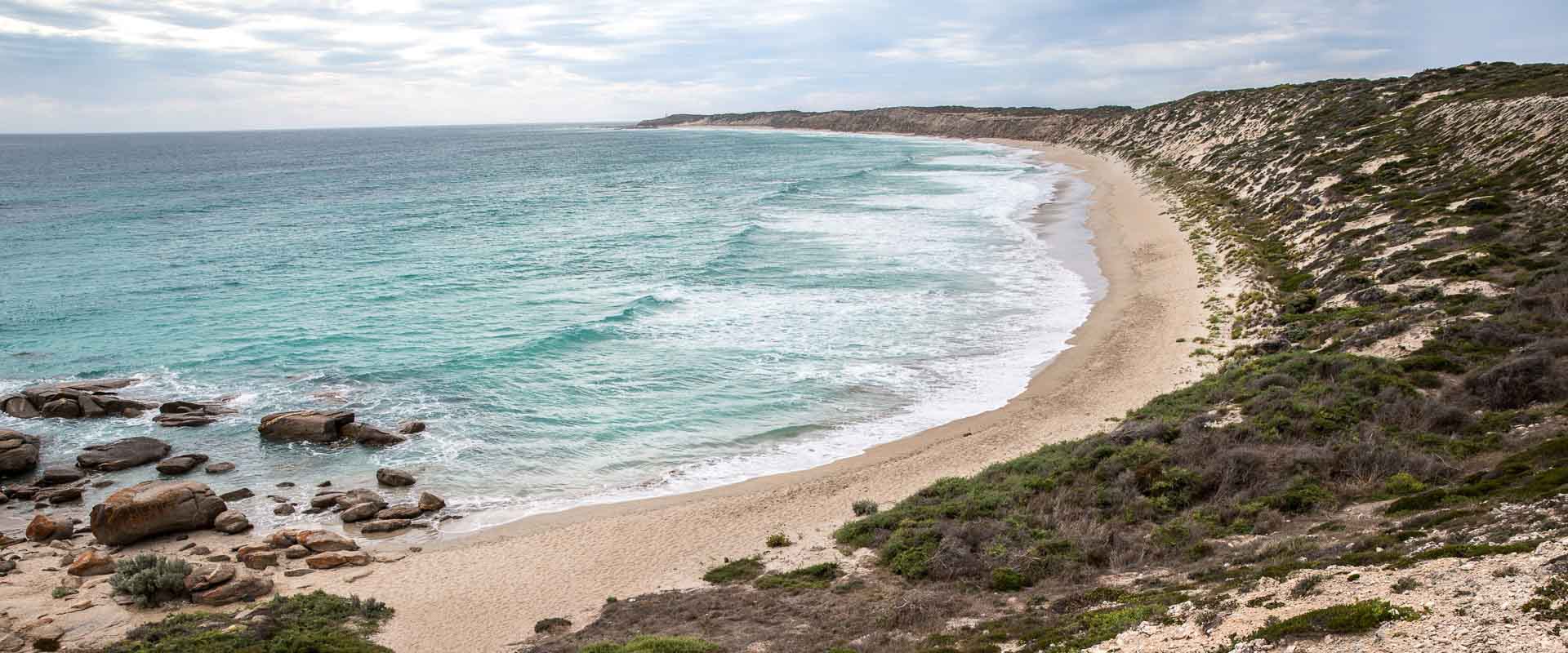
Get back to nature and camp amongst natural vegetation, while enjoying some of the best beachfront views around.

Yorke Peninsula is the perfect destination for a bush camping holiday, with a range of options available across the region.

Bring your self-contained camper, rooftop tent, caravan or tent and book at site at some of most popular private bush camping locations at Marion Bay and Hillocks Drive.

The Yorke Peninsula Council manages 19 designated bush camping locations, with a permit needed to stay at one or all campgrounds.  All 19 locations offer scenic coastal accommodation options, from The Gap, south along the western coastline and under the foot to Goldsmith’s then up the eastern coastline to Parara near Ardrossan.

Please note that each of these 19 bush camping locations has a limited number of sites available.  It’s worth arriving early to your preferred bush camping location, as sites are not reserved and are available on a first-come/first-served basis, but rest assured there is always another bush camping spot nearby.

Pets are welcome at all council bush camping locations, so bring your furry family member with you, but please observe all signage, be considerate of others and take any waste or rubbish with you.

During the cooler months, camp fires are permitted, provided there is no fire ban; but make sure you’re aware of current fire regulations and bring your own firewood. 

Contact a Visitor Information Centre or Outlet before you arrive for more information and to purchase a bush camping permit.  Bush camping permits are available for a night, week, month, or year and valid at any of the 19 campgrounds.

Camping permits for the council’s bush camping locations in the map below can be purchased online, by phone 1800 202 445 or from Yorke Peninsula Council offices at Minlaton, Yorketown or Maitland. 


Campground locations

The Gap

  • Location: 34o14'06.5"S / 137o30'06.6"E
  • Getting there: Located on the northwest coastline, 15 kilometres north of Balgowan.  Access is from Spencer Highway just south of Weetulta, or along the coastal track from Balgowan.
  • Number of sites: 20
  • Toilets: yes
  • Nearest rubbish collection point: Maitland
  • Nearest RV dump point: Maitland
  • Distance from sealed road: 13km

The Bamboos

  • Location: 34o15'10.0"S / 137o30'12.7"E
  • Getting there: Located on the northwest coastline, 12 kilometres north of Balgowan.  Access is via the coastal track from Balgowan.
  • Number of sites: 10
  • Toilets: yes
  • Nearest rubbish collection point: Maitland
  • Nearest RV dump point: Maitland
  • Distance from sealed road: 8km

 
Tiparra Rocks

  • Location: 34o15'50.4"S / 137o30'05.1"E
  • Getting there: Located on the northwest coastline, 8 kilometres north of Balgowan. Access is via the coastal track from Balgowan.
  • Number of sites: 5
  • Toilets: yes
  • Nearest rubbish collection point: Maitland
  • Nearest RV dump point: Maitland
  • Distance from sealed road: 5km

 
Wauraltee

  • Location: 34o35'10.8"S / 137o30'44.0"E
  • Getting there: Situated on the western coastline, 17 kilometres south of Port Victoria on Wauraltee Beach Road.
  • Number of sites: 10
  • Toilets: yes
  • Nearest rubbish collection point: Minlaton
  • Nearest RV dump point: Port Victoria
  • Distance from sealed road: 4.5km
  • *please note that the designated camping area does not include the beach

 
Barker Rocks

  • Location: 34o42'54.9"S / 137o29'17.5"E
  • Getting there: Situated on the west coastline, 12 kilometres north-west of Minlaton, on Barkers Rocks Road.
  • Number of sites: 10
  • Toilets: yes
  • Nearest rubbish collection point: Minlaton
  • Nearest RV dump point: Minlaton
  • Distance from sealed road: 3km

 
Port Minlacowie

  • Location: 34o49'58.1"S / 137o27'35.5"E
  • Getting there: Located on the western coastline, 650 metres north of Minlacowie Road.  Access is via Beegoodyewells Road.
  • Number of sites: 10
  • Toilets: yes
  • Nearest rubbish collection point: Minlaton
  • Nearest RV dump point: Minlaton
  • Distance from sealed road: 8km

Len Barker Reserve

  • Location: 34o55'14.1"S / 137o18'04.9"E
  • Getting there: Located on North Coast Road about halfway between Point Turton and Point Souttar, near the junction of North Coast Road and West Cowie Road.
  • Number of sites: 12
  • Toilets: yes
  • Nearest rubbish collection point: Warooka
  • Nearest RV dump point: Point Turton
  • Distance from sealed road: 6km


Burners

  • Location: 34o54'00.2"S / 137o14'39.7"E
  • Getting there: Situated on the northern coastline of the foot on Point Souttar Road, 12 kilometres west of Point Turton.  Follow the track on the left leading away from Point Souttar beach towards Leven Beach.
  • Number of sites: 30
  • Toilets: yes
  • Nearest rubbish collection point: Burners Beach
  • Nearest RV dump point: Point Turton
  • Distance from sealed road: 15km


Gravel Bay

  • Location: 34o55'55.8"S / 136o59'57.9"E
  • Getting there: Located on the north-western coastline of the foot on Berry Bay Road, 18 kilometres west of Corny Point.  Access is via Light House Road.
  • Number of sites: 5
  • Toilets: yes
  • Nearest rubbish collection point: Corny Point
  • Nearest RV dump point: Warooka
  • Distance from sealed road: 8km


Swincer Rocks

  • Location: 34o58'15.9"S / 136o58'14.7"E
  • Getting there: Located on the north-western coastline of the foot on Wurlie Road, 41 kilometres west of Warooka.
  • Number of sites: 10
  • Toilets: yes
  • Nearest rubbish collection point: Corny Point
  • Nearest RV dump point: Warooka
  • Distance from sealed road: 6km

Gleeson’s Landing

  • Location: 35o00'20.2"S / 136o57'56.8"E
  • Getting there: Located on the western coastline of the foot, 19 kilometres southwest of Corny Point.  Access is from the Corny Point to Marion Bay Road.
  • Number of sites: 40
  • Toilets: yes
  • Nearest rubbish collection point: Gleeson's Landing
  • Nearest RV dump point: Warooka
  • Distance from sealed road: 7km


Daly Head

  • Location: 35o01'26.1"S / 136o56'23.8"E
  • Getting there: Located on the western coastline of the foot, approximately 25 kilometres south of Corny Point. Access is via Marion Bay Road and Daly Head Road.
  • Number of sites: 40
  • Toilets: yes
  • Nearest rubbish collection point: Gleeson's Landing
  • Nearest RV dump point: Warooka
  • Distance from sealed road: 6km

Foul Bay Boat Ramp

  • Location: 35o12'35.1"S / 137o11'21.9"E
  • Getting there: Located on the southern coastline, 1 kilometre southwest of Foul Bay.  Access is via Yorke Highway onto Hundred Line Road, then turn left onto South Coast Road.  The campground is located near the boat ramp.
  • Number of sites: 5
  • Toilets: no
  • Nearest rubbish collection point: Marion Bay
  • Nearest RV dump point: Warooka
  • Distance from sealed road: 16km

Foul Bay

  • Location: 35o10'46.3"S / 137o12'40.0"E
  • Getting there: Located on the southern coastline, 39 kilometres southwest of Warooka.  Access is via Happy Valley Road.
  • Number of sites: 40
  • Toilets: yes
  • Nearest rubbish collection point: Marion Bay
  • Nearest RV dump point: Warooka
  • Distance from sealed road: 12km

Sturt Bay

  • Location: 35o06'28.0"S / 137o24'08.7"E
  • Getting there:  Located on the southern coastline, 13 kilometres south of Warooka. Access is via Sturt Bay Road.
  • Number of sites: 5
  • Toilets: yes
  • Nearest rubbish collection point: Port Moorowie
  • Nearest RV dump point: Warooka
  • Distance from sealed road: 13km

Mozzie Flat

  • Location: 35o06'41.9"S / 137o29'55.0"E
  • Getting there: Located on the southern coastline, 23 kilometres south of Warooka and 17 kilometres south of Yorketown.
  • Number of sites: 5
  • Toilets: yes
  • Nearest rubbish collection point: Port Moorowie
  • Nearest RV dump point: Edithburgh
  • Distance from sealed road: 5km


Goldsmith's

  • Location: 35o08'51.6"S / 137o41'13.0"E 
  • Getting there: Located on the southern coastline, 10 kilometres southwest of Edithburgh. Access is via Troubridge Point Drive, near the corner of Heel Road.
  • Number of sites: 8
  • Toilets: yes
  • Nearest rubbish collection point: Edithburgh
  • Nearest RV dump point: Edithburgh
  • Distance from sealed road: 8km


Wattle Point

  • Location: 35o08'19.0"S / 137o42'08.2"E
  • Getting there: Located on Heel Road, 8 kilometres southwest of Edithburgh.  Access is via Wattle Point Road onto Heel Road.
  • Number of sites: 5
  • Toilets: yes
  • Nearest rubbish collection point: Edithburgh
  • Nearest RV dump point: Edithburgh
  • Distance from sealed road: 4.5km

Parara

  • Location: 34o46'05"S / 137o90'91"E
  • Getting there: Located 4 kilometres south of Ardrossan on the eastern coastline. Access is from Yorke Highway via Parara Road.
  • Number of sites: 15
  • Toilets: yes
  • Nearest rubbish collection point: Parara
  • Nearest RV dump point: Ardrossan
  • Distance from sealed road: 1km


Find out more about the Yorke Peninsula Council’s bush camping locations in the Bush Camping brochure & Bush Camping map.


Water Refills

There are a number of locations across Yorke Peninsula where self-contained campers, vans and motorhomes can access potable water, in addition to the caravan parks.

Ardrossan
Water is available at the short term parking area located on West Terrace.
 
Arthurton
Water is available behind the Arthurton Hall.  There are parking facilities and toilets.
 
Curramulka
The overnight camping area is located behind the Community Tennis Courts on Main Street.  Facilities include mains water, toilets, dump point and barbeque; fees apply (pay at Curramulka General Store).
 
Maitland
Water is available at the Maitland Town Oval. 
 
Port Julia
The Port Julia Camping Ground has a small water tank, with overnight sites available for a small fee payable to the onsite caretaker.
 
Port Victoria
Overnight sites are available at the Port Victoria Oval, with water and dump point available.  Fees apply, payable at the Port Vicotria Kiosk (located by the jetty).
 
Price
Water is available at the Price Community Club.
 
Stansbury
Water is available at the Stansbury boat ramp.

The Yorke Peninsula is the traditional lands of the Narungga (Nharangga) people, who have lived on, and cared for, this country since the beginning of time. We work, live and travel on Nharannga Banggara [Country], and we take time away from those pursuits to acknowledge and pay our deep respects to the Nharangga Elders of the past and present. 

Today, it is essential that we continue to care for and protect our spectacular natural environment. Tread lightly and leave no trace. Learn more about responsible and respectful travel on Yorke Peninsula.